Babadağ has five takeoff sites facing different directions. Wind direction decides which one is open.
Last updated 2026-09-01
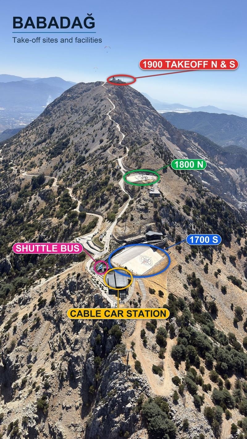
Takeoff sites and facilities.
1) 1900 m, north and south sites
2) 1800 m, north
3) 1700 m, south
4) Shuttle vehicle
5) Cable car station
The cable car runs to 1700. To reach the upper sites you take the free
shuttle that waits next to the station.
Babadağ has five takeoff sites and they face different directions. Which one
is open on a given day is decided by the wind direction, and whether you fly
at all is decided by its strength. Higher is not always better: if the
direction does not match the aspect, that site is closed.
Maximum wind limit
The limit for all sites is 25 km/h, that is 7 m/s. No
takeoff is made above this value. The limit does not change from site to
site; if the wind exceeds it, the mountain is closed for the day. The
official flight directive sets the ground wind limit for flights with a
passenger at 25 km/h as well. For live readings see the
live wind page.
Rating required
Every takeoff site on Babadağ requires a minimum of P3. A
P3 pilot may fly solo on a single seat wing under their own responsibility.
P2 pilots may only fly from the altitude and within the wind limits approved
by an instructor. There is no difference in rating between the sites; the
difference is in wind direction and technical demand. See
local rules for detail.
1700 faces south while 1800 and 1900 North face north, so when one is open
the other is usually closed. Patara faces east and works independently of
both, which makes it the only option when the wind comes from that side.
The lower site, used when the wind is too strong higher up, when the summit clouds over, or in winter when snow closes the upper sites. It is the only site that works in westerly winds.
Altitude Above sea level
1200 m
Coordinates Degrees, minutes, seconds
36°32'56.7"N 29°09'21.0"E
Coordinates Decimal degrees
36.549083, 29.155833
Aspect Direction the site faces
West, southwest, south
Usable wind direction Directions this site accepts
West, southwest and south
Maximum wind speed No takeoff above this
25 km/h (7 m/s)
Surface Takeoff surface
Paved stone
Minimum rating Lowest recommended level
P3 minimum
Access How to reach the site
Cable car or tandem operator vehicles
Road condition Road leading to the site
Stony dirt road
When it is used Conditions that open this site
Winter months, strong wind on the upper sites, cloud on the summit
Ölüdeniz Babadağ 1700 m Takeoff
Main takeoff
The largest and most used takeoff on the mountain. This is the top cable car station and where tandem traffic concentrates, so free flight pilots need to pay attention to the queue and to sharing the layout area.
Altitude Above sea level
1700 m
Coordinates Degrees, minutes, seconds
36°32'20.3"N 29°10'11.0"E
Coordinates Decimal degrees
36.538972, 29.169722
Aspect Direction the site faces
South, southwest, southeast
Usable wind direction Directions this site accepts
Southerly winds
Maximum wind speed No takeoff above this
25 km/h (7 m/s)
Surface Takeoff surface
Paved stone, very wide
Minimum rating Lowest recommended level
P3 minimum
Access How to reach the site
Top cable car station, or tandem operator vehicles
Road condition Road leading to the site
Paved, in good condition
When it is used Conditions that open this site
Whenever southerly winds dominate, which is most of the season
Notes for this site
The local thermal forms just to the right of takeoff. You can look for your first climb there, but so will everyone else, so watch the turn direction and the traffic as you enter it. If you need the upper sites, the free shuttle leaves from this station.
On a busy takeoff, queue and layout discipline is everything.
Ölüdeniz Babadağ 1800 m Takeoff
North takeoff
Faces north, the opposite direction to 1700. This is the site that opens when the wind comes from the northerly sector. It is smaller and steeper, so it asks more of your takeoff technique than 1700 does.
Altitude Above sea level
1800 m
Coordinates Degrees, minutes, seconds
36°32'14.6"N 29°10'18.0"E
Coordinates Decimal degrees
36.537389, 29.171667
Aspect Direction the site faces
North, northwest, northeast
Usable wind direction Directions this site accepts
Northerly winds
Maximum wind speed No takeoff above this
25 km/h (7 m/s)
Surface Takeoff surface
Paved stone
Minimum rating Lowest recommended level
P3 minimum
Access How to reach the site
Free shuttle from the 1700 station
Road condition Road leading to the site
Paved, in good condition
When it is used Conditions that open this site
In northerly winds, when 1700 is closed
Notes for this site
Because the site is narrow and steep, there is little room to abort. If you cannot inflate the wing under control, do not force it here.
The ground beyond the site
At the end of the 1800 site there is a slope of roughly five metres,
then an access road, and beyond that the terrain drops away again in a
cliff. If the takeoff is not completed safely the pilot risks hitting
hard ground or being carried over the edge. In 2026 an amateur pilot was
injured here: he misjudged the wind direction and speed, applied deep
brake too early during the run and stalled the wing. Do not start your
run until the wind direction and speed are properly met.
Ölüdeniz Babadağ 1900 m North Takeoff
Summit, north
One of the two summit sites, facing north. It works in the same wind as 1800 but gives a higher start.
Altitude Above sea level
1900 m
Coordinates Degrees, minutes, seconds
36°31'48.9"N 29°10'53.0"E
Coordinates Decimal degrees
36.530250, 29.181389
Aspect Direction the site faces
North, northwest, northeast
Usable wind direction Directions this site accepts
Northerly winds
Maximum wind speed No takeoff above this
25 km/h (7 m/s)
Surface Takeoff surface
Partly paved stone
Minimum rating Lowest recommended level
P3 minimum
Access How to reach the site
Free shuttle from the 1700 station
Road condition Road leading to the site
Paved, in good condition
When it is used Conditions that open this site
In northerly winds, when you want a higher start
Ölüdeniz Babadağ 1900 m Patara Takeoff
Summit, east
The second summit site. It works in easterly and southeasterly winds and is the only takeoff that opens in those directions. When the wind comes from the east and everything else is closed, this is where you fly.
Altitude Above sea level
1900 m
Coordinates Degrees, minutes, seconds
36°31'47.2"N 29°10'59.1"E
Coordinates Decimal degrees
36.529778, 29.183083
Aspect Direction the site faces
East, southeast, south
Usable wind direction Directions this site accepts
Easterly and southeasterly winds
Maximum wind speed No takeoff above this
25 km/h (7 m/s)
Surface Takeoff surface
Partly paved stone
Minimum rating Lowest recommended level
P3 minimum
Access How to reach the site
Free shuttle from the 1700 station
Road condition Road leading to the site
Paved, in good condition
When it is used Conditions that open this site
In easterly and southeasterly winds
Getting up the mountain
Private vehicles cannot enter the takeoff area. The cable car runs to 1700
metres and a free shuttle continues to the upper sites. Times, fares and
road conditions are on the
getting there page.
Advertisement
Next step
Once the takeoff decision is made, the next subject is the landing. See
landing areas for the Belcekız approach and
the alternatives, and local rules for traffic
priorities.
Coordinates, aspects, surfaces, access and road conditions come from local
sources. Site conditions and rules change over time, verify them on the ground
before you fly.